Search Term Record
Metadata
Search Term |
Road |
Number of Object records |
0 |
Number of Photo records |
83 |
Number of Archive records |
1 |
Number of Library records |
0 |
Related Records
-
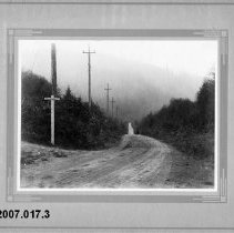
2007.017.3 - North Road and Barnet Highway
Black and white photograph depicting the intersection of North Rd and Barnet Hwy. Man on Motorcyle poses on the road. Housed in a grey cardboard frame.
Record Type: Photo
-
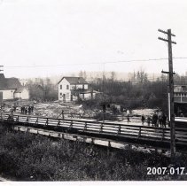
2007.017.39 - Aftermath of second Coquitlam fire
Black and white photograph looking east of a Dewdney Trunk bridge (now Kingsway) after the 1920 fire. Displays some houses, a church, and a wooden bridge. Chinese laundry centre left.
Record Type: Photo
-
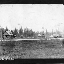
2007.017.59 - Flint Road and Fraser Avenue
large black and white photograph depicting an area of Fraser Ave and Flint Rd. On Front: Poroodleridge 3775 On back: Area of Flint Road and Fraser Avenue, easrly 1920's
Record Type: Photo
-
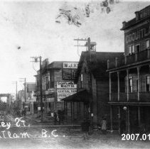
2007.017.60a - Coquitlam Hotel on Dewdney
Large black and white photographs depicting Dewdney St. On front: Dudney St Cogutlam BC
Record Type: Photo
-
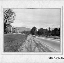
2007.017.62 - Lougheed
Large black and white photograph depicting what is now Lougheed Highway by Riverview Hospital. Written on reverse: Essondale
Record Type: Photo
-
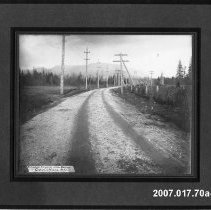
2007.017.70a-c - Finished Road
Large black and white photographs depicting finished road in Port Coquitlam
Record Type: Photo
-
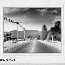
2007.017.76 - Shaughnessy Street looking north
Large black and white photograph depicting Shaughnessy street. Reverse: Shaughnessy Street looking north Kingsway bottom cross street
Record Type: Photo
-
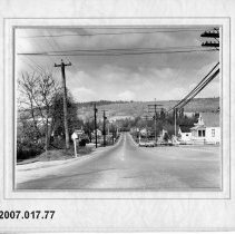
2007.017.77 - Shaughnessy Street
Large black and white photograph depicting Shaughnessy Street. Reverse: Shaughnessy Street west Pitt River Road 1960
Record Type: Photo
-
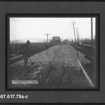
2007.017.79a-c - Constructing Flint Street
Image of road being constructing at the stage of laying gravel/rocks. Man looks towards camera with shovel in hand. Road leads into background. Road lined with telephone poles. A house in the background at TCL. Tape with "First, of three layers rock | Coquitlam, B.C." written is printed onto image at BL
Record Type: Photo
-
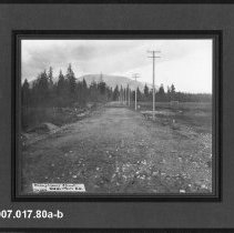
2007.017.80a-b - Shaughnessy St
photograph of a gravel road leading into trees and mountains pictured in background grassy park area (Aggie Grounds) to the right of the road "Shaughnessy St north from railroad tracks" noted on back of print b. Sticker on back of print b notes "Old Aggie GR." (grounds) "Shaughnessy Street, Feb 1912 Coquitlam, B.C" on tape printed at BL
Record Type: Photo
-
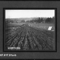
2007.017.81a-b - Road construction, Pitt River Road
Large black and white photographs depicting the first staged of construction with loam on the bottom of the road. 81b Obverse: "Pitt River Road looking towards red Bridge from corner of Shaughnessy St "House on right belonged to Vint "Left background Watts "Circa 1910?
Record Type: Photo
-
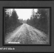
2007.017.82a-b - Pitt River Road
large black and white photograph depicting The Pitt River Road and red bridge. On 82b Reverse: Pitt River Road + Red Bridge Looking from Essondale Side Possibly standing on railroad tracks
Record Type: Photo
-
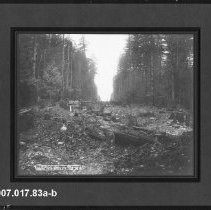
2007.017.83a-b - New high-land road, Coquitalm BC
photograph of road being constructed. forest on either side with cut trees along middle sightline that will be path for road. cut logs seen stacked in mid-background. tape with notes printed onto photograph at BL that reads: New high-land road | Coquitlam, B.C. "W.T.Cooksley, Photo, New Westminster, B.C" in small print at BC. - year range based on Cooksley's photography business
Record Type: Photo
-
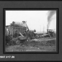
2007.017.86 - Portable Rock Crushing Plant
Large black and white photograph depicting a portable rock crushing plant in use. Obverse: "Portable Rock Crushing Plant, Coquitlam, BC"
Record Type: Photo
-
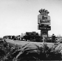
2013.017.320 - Best Western PoCo Motor Inn
Best Westerm PoCo Motor Inn & Pantry Family Restaurant. Lougheed and Coast Meridian
Record Type: Photo
-
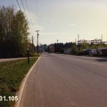
2019.001.105 - 2580-2640 Mary Hill Road and 2179 Wilson Avenue
2580-2640 Mary Hill Road and 2179 Wilson Ave, Port Coquitlam. Taken on April 8, 1992. Vehicles can be seen further down the road. On the left side of the road are trees and a telephone line and on the right side of the road are some construction materials.
Record Type: Photo
-
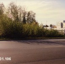
2019.001.106 - 2580-2640 Mary Hill Road and 2179 Wilson Avenue
2580-2640 Mary Hill Road and 2179 Wilson Ave, Port Coquitlam. Taken on April 8, 1992 from across the street. On the right side are stacks of buildings materials and on the left side are trees with a cut-off white building.
Record Type: Photo
-
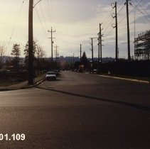
2019.001.109 - 2580-2640 Mary Hill Road and 2179 Wilson Ave
2580-2640 Mary Hill Road and 2179 Wilson Ave, Port Coquitlam. Taken on April 8, 1992 at an intersection. The road turns from the left and there are several cars parked down the street. There are multiple telephone lines on either side of the street and a few trees on the left side. On the right is a large metallic structure.
Record Type: Photo
-
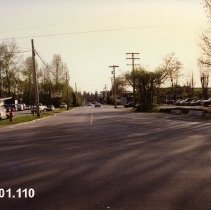
2019.001.110 - 2580-2640 Mary Hill Road and 2179 Wilson Ave
2580-2640 Mary Hill Road and 2179 Wilson Ave, Port Coquitlam. Taken on April 8, 1992 at an intersection. On the left side of the street is one-story building with a parking lot out front, there are many cars parked. On the right side is another parking lot with many cars parked. There are two cars seen down the road and there are trees and telephone lines on either side of the street. A fire hydrant and street sign on the left corner of the inter...
Record Type: Photo
-
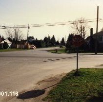
2019.001.116 - 1574 Prairie Ave Neighbourhood
1574 Prairie Ave Port Coquitlam. Taken on May 3, 1992. There are three duplicates within the collection. Taken at a four way intersection in a neighbourhood, a traffic sign at the right corner of the intersection. Houses, trees, and telephone lines on either side of the street. A red car can be seen on the left side of the street.
Record Type: Photo