
Archive Record
Images
Metadata
Catalog Number |
2023.FIC.9 |
Object Name |
Map |
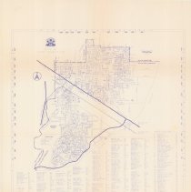
Description |
Map of the City of Port Coquitlam, March 1998. Blue print with Lougheeed Highway and Mary Hill Bypass in bold. Title and city crest in upper left. Streets, public facilities, and schools are listed across bottom. Coordinate measures along all sides. "DWG\MAPS\ROAD-CL". |
Title |
City of Port Coquitlam |
Date |
March 1998 |
Condition |
Good |
Search Terms |
Map Maps Port Coquitlam |