
Archive Record
Images
Metadata
Catalog Number |
2006.006.82 |
Object Name |
Plan |
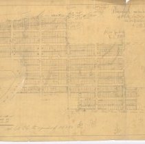
Description |
Hand-drawn map of a proposed subdivision of the North Westerly portion of D.L. 174, and of 29 acres on Pitt River Road. Multipe pencil annotations and equations. |
Title |
Proposed Subdivision of North Westerly Portion & 29 Acres on Pitt River Road of D.L. 174 |
Date |
c.1911 |
Condition |
Poor |
Search Terms |
Map Maps Pitt River Road Port Coquitlam |