
Archive Record
Images
Metadata
Catalog Number |
2015.008.3 |
Object Name |
Map |
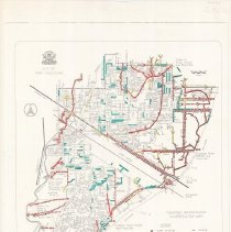
Description |
Map of fish-bearing and non-fish-bearing waterways in Port Coquitlam, to be used as a guide for determining the classification of stream habitats. Map is annotated in red, blue, and yellow. Text in lower left, legend in lower right. |
Title |
Fisheries Watercourse Classification Map |
Date |
July 1998 |
Condition |
Good |
Search Terms |
Maps Map Port Coquitlam Water Fish |