Archives
Enter a word or phrase to perform a general search across all records in the Archives catalog. You can also browse records in the catalog without performing a search.
Search Tips
- Searches are not case sensitive.
- Searching for multiple words connects them with OR by default. Matching records can contain any of the words.
- Connect multiple words with AND if you only want to see records containing both words.
- Use quotation marks to search for a phrase.
- Place an asterisk (*) at the end of a word as a wildcard.
173 results found. Records searched: 173
-
2005.007.5 - Map
A map of the city of Port Coquitlam with a list of all the buisnesses and their addresses written by the Port Coquitlam Board of Trade.
Record Type: Archive
-
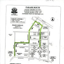
2005.007.50 - Map
A map of the parade route for the 1998 May Day Parade from March 1998.
Record Type: Archive
-
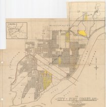
2006.006.77 - Map
Map of the City of Port Coquitlam, B.C. Compiled from official sources by the Clarke & Stuart Co. Limited, 550 Seymour Street Vancouver B.C., July 1920. Blocks 255, 288, and 231 in lower right have been hand-coloured to reflect 5-part legend. Some pencil annotations. Watermarked with a "Beaver & Bond" logo.
Record Type: Archive

-
2006.006.78 - Map
Map of the City of Port Coquitlam, B.C. Compiled from official sources by the Clarke & Stuart Co. Limited, 550 Seymour Street Vancouver B.C., July 1920. Multiple pencil annotations; legend in lower right dated April 5th, 1951. Map has been hand-coloured blue, pink, and brown to identify open/closed roads and acreage land.
Record Type: Archive
-
2006.006.79 - Map
Map of the City of Port Coquitlam, B.C. Compiled from official sources by the Clarke & Stuart Co. Limited, 550 Seymour Street Vancouver B.C., July 1920. Areas have been highlighted in yellow, select roads coloured brown. Multiple pencil annotations including James Park School in upper left. Watermarked with a "Beaver & Bond" logo. Top edge has been cut irregularly.
Record Type: Archive
-
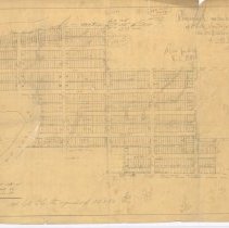
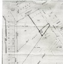
2006.006.82 - Plan
Hand-drawn map of a proposed subdivision of the North Westerly portion of D.L. 174, and of 29 acres on Pitt River Road. Multipe pencil annotations and equations.
Record Type: Archive
-
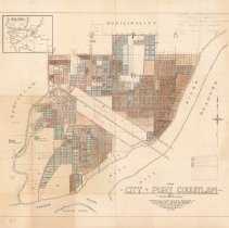
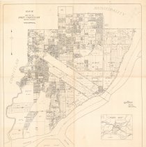
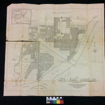
2006.006.83 - Map
Map of Port Coquitlam. Title and scale in upper left, index map of surrounding municipalities in lower right. Compiled from land registry office records.
Record Type: Archive
-
2006.006.84 - Photograph
Black-and-white aerial/satellite image of Port Coquitlam from March 12, 1969. 1" = 1000' scale. Depicts 6200 acres. Printed on card.
Record Type: Archive

-
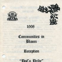
2010.013.12 - Correspondence
A collection of documents regarding the Communities in Bloom competition. In the collection is a highlighted map of Port Coquitlam, details on the Community in Bloom committee and their plans, and emails about the Communities in Bloom competition.
Record Type: Archive
-
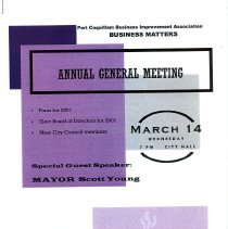
2010.013.23 - Report, Annual
A collection of documents related to Port Coquitlam Business Improvement Association. (BIA) This collection contains a hand drawn map of Downtown PoCo, two annual general meetings for 2001 and 2003, a Business Matters newsletter, a collage from the the Community Art Centre that was supported by Port Coquitlam's Business Community, a chronology of Port Coquitlam's history, pictures from the Port Coquitlam Business Improvement Association website....
Record Type: Archive
-
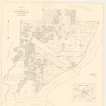
2011.014.3 - Map
Map of Port Coquitlam. Title and scale bar in upper left, index map of surrounding municipalities in lower right. Compiled from Land Registry Office records. Original map date May 14, 1952. Revised July 1963. Pencil markings in upper right corner.
Record Type: Archive
-
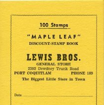
2013.012.1 - Book, Stamp
A stampbook titled "100 Stamps 'Maple Leaf' Discount-Stamp Book" from "Lewis Bros General Store 2392 Dewdney Trunk Road Port Coquitlam Phone 189 The Biggest Little Store in town." The copyright is 1950 and is held by "Cascade Supply LTD. Oliver, B.C."
Record Type: Archive
-
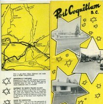
2013.019.2a - Brochure
1/2 Port Coquitlam brochures promoting the city, "published in the interests of the community by the Port Coquitlam City Council and Board of Trade", includes map of Port Coquitlam
Record Type: Archive
-
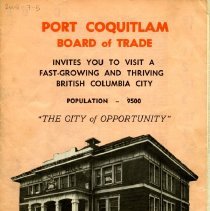
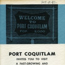
2013.019.43a - Pamphlet
"Welcome to Port Coquitlam Pop. 8000 Port Coquitlam Invites You to Visit a Fast-Growing and Thriving British Columbia City "The City of Opportunity"" pamphlet. Includes: city history, board of trade members, map, local businesses, brief overviews of different city events or activities
Record Type: Archive
-
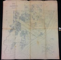
2014.004.1 - Map
Map of the City of Port Coquitlam from July 1920 Compiled from Official Sources by the Clarke & Stuart Co. Limited 550 Seymour Street Vancouver BC July 1920 Also includes small, "Key map" of cities surrounding Port Coquitlam
Record Type: Archive
-
2014.004.2 - Map
Plan of the City of Port Coquitlam from 1952 Compiled from Land Registry Office Records Revised May 1959 Includes Index Map of Surrounding cities
Record Type: Archive
-
2014.019.48 - Map
A series of maps on the Excavation of the Mary Hill Bypass (DhRq 21). Contains details on the layout and the division of excavation blocks.
Record Type: Archive
-
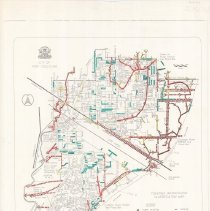
2015.008.3 - Map
Map of fish-bearing and non-fish-bearing waterways in Port Coquitlam, to be used as a guide for determining the classification of stream habitats. Map is annotated in red, blue, and yellow. Text in lower left, legend in lower right.
Record Type: Archive
-
2015.008.4 - Map
Map of Port Coquitlam. Parks are outlined in green and schools in red. Garbage cans are indicated by red dots.
Record Type: Archive
-
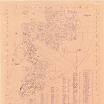
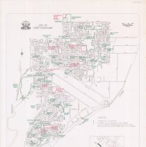
2015.008.6 - Map
Map of Port Coquitlam . Blue print on dark beige paper. Title in upper left, scale bar in upper right. Roads, public facilities, and schools are listed across bottom of map.
Record Type: Archive